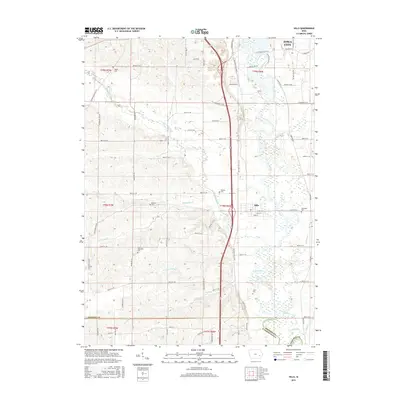
2015 Map of Hills
USGS Topo · Published 2015About this map
The Iowa River corridor south of Iowa City reveals a landscape defined by its winding waterways and historic family burials. The town of Hills serves as a central hub, surrounded by a complex network of tributaries including Old Mans Creek, Snyder Cr, and Dirty Face Cr. This 2015 survey illustrates how the lowlands of the river valley have been partitioned by a grid of county roads, such as Sand Rd SE and Oak Crest Hill Rd SE, while maintaining the distinct agrarian boundaries of the Public Land Survey System. For genealogists and local historians, the map is particularly valuable for its documentation of several pioneer-era burial grounds, including the Welsh Cem in the northwest, Saint Stanislaus Cem near Picayune Cr, and the Sandtown Cem east of Hills. These small cemeteries are critical markers of the early European settlement patterns in Johnson County.
Find a feature on this map
80 named features on this map. Tap any name to fly to it.
Don’t see what you’re looking for? This feature index may not catch every label — zoom into the map to look around manually.
Map Details
Editions of this 2015 Hills Map
This is the sole edition of this map. No revisions or reprints were ever made.
Other maps of this area

1891 · Iowa City
USGS Topo · 1:62,500

1894 · West Liberty
USGS Topo · 1:62,500

1901 · Stanwood
USGS Topo · 1:125,000

1903 · Fairfax
USGS Topo · 1:125,000

1938 · Iowa City
USGS Topo · 1:62,500

1958 · Davenport
USGS Topo · 1:250,000

1961 · Davenport
USGS Topo · 1:250,000

1962 · Davenport
USGS Topo · 1:250,000

1965 · Williamstown
USGS Topo · 1:24,000
1965 · Tiffin
USGS Topo · 1:24,000