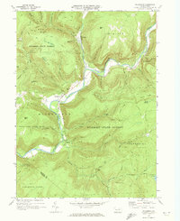
1970 Map of Hillsgrove
USGS Topo · Published 1973About this map
Loyalsock Creek carves a winding path through this corner of the Endless Mountains, defining the geography of the Hillsgrove and Ogdonia communities. The 1970 landscape is dominated by the dense woodlands of the Wyoming State Forest and State Game Lands No 134, where elevations reach their peaks at High Knob and Bear Mtn. The map documents a classic Appalachian mountain economy transitioned to recreation and conservation, featuring the Loyalsock Trail and several scenic overlooks like Hoagland Vista. Along the creek, a Covered Bridge and a Ford near the Sullivan and Lycoming county line mark traditional crossing points. Remote water features such as Angel Falls and Hunters Lake are tucked into the steep drainages of Brunnerdale Run and Pine Run, highlighting the area's intricate network of mountain streams.
Find a feature on this map
52 named features on this map. Tap any name to fly to it.
Don’t see what you’re looking for? This feature index may not catch every label — zoom into the map to look around manually.
Map Details
Editions of this 1970 Hillsgrove Map
This is the sole edition of this map. No revisions or reprints were ever made.
Other maps of this area

1927 · Eagles Mere
USGS Topo · 1:48,000

1930 · Warrensville
USGS Topo · 1:62,500

1932 · Eagle Mere
USGS Topo · 1:62,500

1934 · Warrensville
USGS Topo · 1:62,500

1942 · Canton
USGS Topo · 1:62,500

1943 · Powell
USGS Topo · 1:62,500

1944 · Canton
USGS Topo · 1:62,500

1945 · Powell
USGS Topo · 1:62,500

1953 · Warrensville
USGS Topo · 1:62,500

1953 · Eagles Mere
USGS Topo · 1:62,500
Featured Places
- Hillsgrove Township, PA
- Wissingers, Fox Township
- Forks Township, PA
- Elkland Township, PA
- Plunketts Creek Township, PA