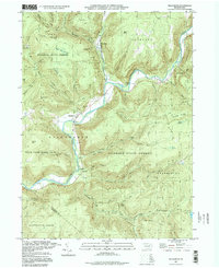
1995 Map of Hillsgrove
USGS Topo · Published 1998About this map
Loyalsock Creek meanders through the heart of the central Sullivan County Highlands, carving a deep valley that defines the local landscape. The settlement of Hillsgrove sits at the confluence of several mountain runs, serving as a gateway to the vast Wyoming State Forest and the nearby State Game Lands No 134. The terrain is characterized by high points like High Knob and Round Top, offering dramatic overlooks such as Hoagland Vista. Evidence of the region's wilderness character and early infrastructure is visible in landmarks like the Covered Bridge and the remote waters of Hunters Lake. The convergence of Elk Creek and Ogdonia Creek near the small community of Ogdonia illustrates a drainage pattern that has historically dictated settlement and travel routes through these narrow valleys.
Find a feature on this map
56 named features on this map. Tap any name to fly to it.
Don’t see what you’re looking for? This feature index may not catch every label — zoom into the map to look around manually.
Map Details
Editions of this 1995 Hillsgrove Map
This is the sole edition of this map. No revisions or reprints were ever made.
Other maps of this area

1927 · Eagles Mere
USGS Topo · 1:48,000

1930 · Warrensville
USGS Topo · 1:62,500

1932 · Eagle Mere
USGS Topo · 1:62,500

1934 · Warrensville
USGS Topo · 1:62,500

1942 · Canton
USGS Topo · 1:62,500

1943 · Powell
USGS Topo · 1:62,500

1944 · Canton
USGS Topo · 1:62,500

1945 · Powell
USGS Topo · 1:62,500

1953 · Warrensville
USGS Topo · 1:62,500

1953 · Eagles Mere
USGS Topo · 1:62,500
Featured Places
- Hillsgrove Township, PA
- Wissingers, Fox Township
- Forks Township, PA
- Elkland Township, PA
- Plunketts Creek Township, PA