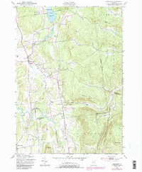
1948 Map of Hinesburg
USGS Topo · Published 1987About this map
The La Platte River and Lewis Creek anchor this Vermont landscape, which traces the agricultural and early industrial character of the region during the mid-20th century. Based on 1948 fieldwork with 1980s updates, the map highlights the settlement patterns of Hinesburg and South Hinesburg, where the local economy was historically tied to the numerous quarries and a sawmill visible along the watercourses. The terrain is defined by prominent elevations such as Lincoln Hill, Texas Hill, and Mount Pritchard, while Lake Iroquois sits at the northern boundary. Smaller communities like Mechanicsville and Rhode Island Corner appear alongside family-named landmarks and rural infrastructure, including a Windmill and a small Cem. The map also captures the convergence of several township boundaries, including St George, Williston, and Monkton, showing how property and civic lines respect the natural ridges and valleys of the Green Mountain foothills.
Find a feature on this map
33 named features on this map. Tap any name to fly to it.
Don’t see what you’re looking for? This feature index may not catch every label — zoom into the map to look around manually.
Map Details
Editions of this 1948 Hinesburg Map
5 editions found

Other maps of this area

1903 · Middlebury
USGS Topo · 1:62,500

1905 · Middlebury
USGS Topo · 1:62,500

1906 · Burlington
USGS Topo · 1:62,500

1919 · Burlington
USGS Topo · 1:62,500

1919 · Lincoln Mountain
USGS Topo · 1:62,500

1920 · Lincoln Mountain
USGS Topo · 1:48,000

1920 · Middlebury
USGS Topo · 1:62,500

1921 · Richmond
USGS Topo · 1:48,000

1921 · Lincoln Mountain
USGS Topo · 1:62,500

1924 · Camels Hump
USGS Topo · 1:62,500