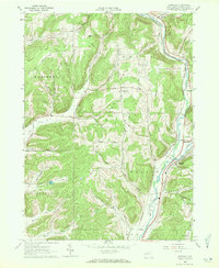
1971 Map of Hinsdale
USGS Topo · Published 1971About this map
Ischua Creek flows southward through a landscape defined by deep valleys and prominent ridges as it moves toward its junction with Olean Creek. This 1961 field-checked survey reveals the valley's reliance on both rail and road infrastructure, with the Pennsylvania and Erie Lackawanna railroads tracing the watercourses. The settlements of Hinsdale, Ischua, and Maplehurst anchor the local geography, surrounded by numerous named hollows and hills that suggest a legacy of family landholdings and rural development.
Find a feature on this map
45 named features on this map. Tap any name to fly to it.
Don’t see what you’re looking for? This feature index may not catch every label — zoom into the map to look around manually.
Map Details
Editions of this 1971 Hinsdale Map
This is the sole edition of this map. No revisions or reprints were ever made.
Other maps of this area

1898 · Olean
USGS Topo · 1:62,500

1900 · Salamanca
USGS Topo · 1:62,500

1924 · Ellicottville
USGS Topo · 1:62,500

1924 · Franklinville
USGS Topo · 1:62,500

1938 · Salamanca
USGS Topo · 1:62,500

1938 · Olean
USGS Topo · 1:62,500

1941 · Ellicottville
USGS Topo · 1:62,500

1942 · Franklinville
USGS Topo · 1:62,500

1943 · Olean
USGS Topo · 1:62,500

1943 · Salamanca
USGS Topo · 1:62,500