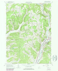
1979 Map of Hinsdale
USGS Topo · Published 1980About this map
The confluence of Ischua Creek and Olean Creek dictates the development of this eastern Cattaraugus County landscape, where the settlements of Hinsdale, Maplehurst, and Ischua are tethered to the valley floor. Transportation corridors, including the Conrail line and several local valley roads, follow the natural breaks between heavily wooded ridges like Bozard Hill and Cooper Hill. This late 1970s revision highlights the persistence of rural institutions, such as the Union Valley Ch and Maple Grove Cem, alongside mid-century infrastructure like the Olean Municipal Airport. The map's detail reveals a landscape defined by hollows—such as Gile Hollow and Morgan Hollow—which served as the primary arteries for family homesteads and small-scale agriculture throughout the township's history. Occasional Oil Well and Gravel Pit labels indicate the quiet presence of local industry amidst the Reforestation Area.
Find a feature on this map
54 named features on this map. Tap any name to fly to it.
Don’t see what you’re looking for? This feature index may not catch every label — zoom into the map to look around manually.
Map Details
Editions of this 1979 Hinsdale Map
This is the sole edition of this map. No revisions or reprints were ever made.
Other maps of this area

1898 · Olean
USGS Topo · 1:62,500

1900 · Salamanca
USGS Topo · 1:62,500

1924 · Ellicottville
USGS Topo · 1:62,500

1924 · Franklinville
USGS Topo · 1:62,500

1938 · Salamanca
USGS Topo · 1:62,500

1938 · Olean
USGS Topo · 1:62,500

1941 · Ellicottville
USGS Topo · 1:62,500

1942 · Franklinville
USGS Topo · 1:62,500

1943 · Olean
USGS Topo · 1:62,500

1943 · Salamanca
USGS Topo · 1:62,500