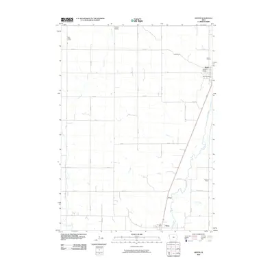
2010 Map of Hinton
USGS Topo · Published 2010About this map
The Floyd River valley defines the eastern landscape of this Plymouth County region, where the settlements of Hinton and Merrill anchor the local community. This 2010 survey illustrates a well-organized agricultural grid intersected by major natural drainage systems, including Perry Creek to the west and Carter Creek to the south. Genealogists will find significant value in the documentation of several local burial grounds, such as Saint Pauls Lutheran Cemetery, Saint Joseph Cemetery, and Melbourne Cemetery. The presence of the Merrill Post Office and Hinton Post Office indicates the established civic centers of these rural townships. Between these primary hubs lies the small locale of Wren, situated along the western bank of the river. The map also traces the section-line road network, featuring routes like Melbourne RD and Ideal RD that connect the isolated farmsteads across the prairie terrain.
Find a feature on this map
35 named features on this map. Tap any name to fly to it.
Don’t see what you’re looking for? This feature index may not catch every label — zoom into the map to look around manually.
Map Details
Editions of this 2010 Hinton Map
This is the sole edition of this map. No revisions or reprints were ever made.
Other maps of this area

1955 · Sioux City
USGS Topo · 1:250,000

1958 · Sioux City
USGS Topo · 1:250,000

1959 · Sioux City
USGS Topo · 1:250,000

1962 · Le Mars
USGS Topo · 1:62,500

1962 · Union Center
USGS Topo · 1:62,500

1963 · Sioux City North
USGS Topo · 1:24,000

1964 · James
USGS Topo · 1:24,000

1964 · Hinton
USGS Topo · 1:24,000
1964 · Millnerville
USGS Topo · 1:24,000
1969 · Brunsville
USGS Topo · 1:24,000