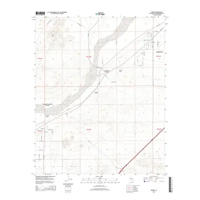
2015 Map of Hodge
USGS Topo · Published 2015About this map
The Mojave River corridor defines this high desert landscape, carving a path between Iron Mtn and the expanse of the Mojave Desert. This 2015 survey details the intersection of regional infrastructure and isolated desert settlements, centered on the community of Hodge and the nearby Johnstons Corner. The map reveals a transition from organized township grids to an intricate network of desert tracks with names evoking the region's western heritage, such as Gunsmoke Rd, Bonanza Trl, and Miners Trl. To the south, the dry bed of Wild Wash winds through Brisbane Valley, while the northeast corner shows the suburban reach of Barstow extending toward Depue Airport. The presence of the Barstow-Victorville Division boundary reflects the complex land management of this San Bernardino County transit corridor.
Find a feature on this map
48 named features on this map. Tap any name to fly to it.
Don’t see what you’re looking for? This feature index may not catch every label — zoom into the map to look around manually.
Map Details
Editions of this 2015 Hodge Map
This is the sole edition of this map. No revisions or reprints were ever made.
Other maps of this area

1932 · Barstow
USGS Topo · 1:125,000

1934 · Barstow
USGS Topo · 1:125,000

1953 · San Bernardino
USGS Topo · 1:250,000

1956 · San Bernardino
USGS Topo · 1:250,000

1956 · Hawes
USGS Topo · 1:62,500

1956 · Barstow
USGS Topo · 1:62,500

1956 · Helendale
USGS Topo · 1:24,000
1956 · Victorville
USGS Topo · 1:62,500

1957 · Apple Valley
USGS Topo · 1:62,500

1957 · San Bernardino
USGS Topo · 1:250,000