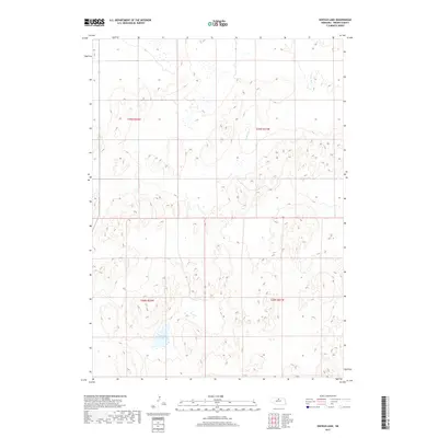
2017 Map of Hofeld Lake
USGS Topo · Published 2017About this map
Hofeld Lake sits at the heart of this North-Central Nebraska landscape, illustrating the quiet, water-scarce character of the Sandhills region in Brown County. The terrain is defined by its drainage patterns, most notably the winding course of Long Pine Cr as it makes its way through the northeastern and central sections of the survey area. This 2017 study captures a specific moment in the public land survey system, clearly delineating the boundaries of t29n r22w, t29n r21w, t28n r22w, and t28n r21w. The sparse labels reflect the open nature of this prairie country, where water features like the central lake are critical landmarks for local navigation and land management.
Find a feature on this map
6 named features on this map. Tap any name to fly to it.
Don’t see what you’re looking for? This feature index may not catch every label — zoom into the map to look around manually.
Map Details
Editions of this 2017 Hofeld Lake Map
This is the sole edition of this map. No revisions or reprints were ever made.
Other maps of this area

1954 · Ainsworth SW
USGS Topo · 1:24,000

1954 · Ainsworth
USGS Topo · 1:24,000

1954 · Long Pine
USGS Topo · 1:24,000

1955 · O'Neill
USGS Topo · 1:250,000

1959 · O'Neill
USGS Topo · 1:250,000

1969 · O'Neill
USGS Topo · 1:250,000

1982 · Lost Lake Ranch
USGS Topo · 1:24,000

1982 · Hofeld Lake
USGS Topo · 1:24,000

1982 · Raven
USGS Topo · 1:24,000
1982 · Raven SW
USGS Topo · 1:24,000