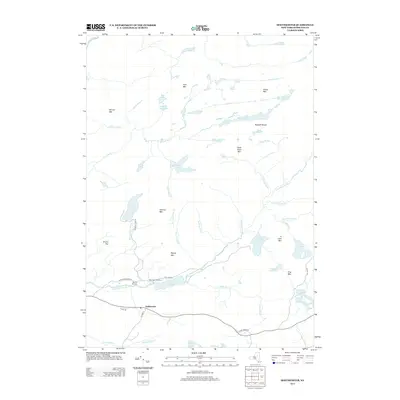
2013 Map of Hoffmeister
USGS Topo · Published 2013About this map
Hoffmeister serves as the primary settlement node in this portion of the Adirondacks, situated along Co Hwy 17 and Leons Rd. The landscape is defined by an intricate network of waterways and high ground, including the Metcalf Chain of Lakes and the prominent Metcalf Range. To the north of the main settlement, Mountain Home sits near the Spruce Hill Cem, providing a localized point of interest for genealogists and local historians. The drainage patterns are dominated by the S Br West Canada Cr, which winds through the central valley, and various smaller tributaries like Mad Tom Brook and Roaring Brook. Notable peaks such as Signal Mtn, Wilmurt Mtn, and Buck Pond Mtn surround the numerous glacial lakes, including the large Wilmurt Lake and the smaller Split Rock Lake at the northern boundary. The presence of features like The Floe along the river indicates the varied hydrologic character of this mountain environment.
Find a feature on this map
52 named features on this map. Tap any name to fly to it.
Don’t see what you’re looking for? This feature index may not catch every label — zoom into the map to look around manually.
Map Details
Editions of this 2013 Hoffmeister Map
This is the sole edition of this map. No revisions or reprints were ever made.
Other maps of this area

1900 · Canada Lake
USGS Topo · 1:62,500

1900 · Wilmurt
USGS Topo · 1:62,500

1901 · Old Forge
USGS Topo · 1:62,500

1902 · Wilmurt
USGS Topo · 1:62,500

1903 · West Canada Lakes
USGS Topo · 1:62,500

1904 · Piseco Lake
USGS Topo · 1:62,500

1906 · Piseco Lake
USGS Topo · 1:62,500

1908 · Piseco Lake
USGS Topo · 1:62,500

1950 · Utica
USGS Topo · 1:250,000
1954 · Ohio
USGS Topo · 1:62,500