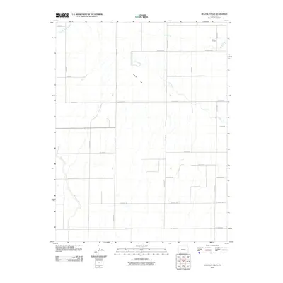
2010 Map of Holcolm Hills
USGS Topo · Published 2010About this map
Holcolm Hills defines the central terrain of this high plains landscape in El Paso County. The area is characterized by a sparse network of ranch roads and drainages that feed into the larger Arkansas River basin. Significant watercourses including Steels Fork, Horse Creek, and the East Branch Brackett Creek cut through the landscape, dictating the placement of early routes such as Falcon Hwy and Washington Rd. For local historians and genealogists, the Myers Cemetery in the northeast corner serves as a critical landmark of early settlement. The road names themselves, such as Guthrie Rd, Salladay Rd, and Vorenburg Rd, likely reflect the ranching families who established the homesteads and property boundaries still visible in the early 21st century.
Find a feature on this map
33 named features on this map. Tap any name to fly to it.
Don’t see what you’re looking for? This feature index may not catch every label — zoom into the map to look around manually.
Map Details
Editions of this 2010 Holcolm Hills Map
This is the sole edition of this map. No revisions or reprints were ever made.
Other maps of this area

1893 · Big Springs
USGS Topo · 1:125,000

1953 · Denver
USGS Topo · 1:250,000
1954 · Ellicott
USGS Topo · 1:24,000
1954 · Haegler Ranch
USGS Topo · 1:24,000

1954 · Pueblo
USGS Topo · 1:250,000

1957 · Denver
USGS Topo · 1:250,000

1957 · Pueblo
USGS Topo · 1:250,000

1958 · Pueblo
USGS Topo · 1:250,000

1958 · Denver
USGS Topo · 1:250,000

1960 · Denver
USGS Topo · 1:250,000