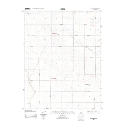
2013 Map of Holcolm Hills
USGS Topo · Published 2013About this map
Holcolm Hills dominates this high plains landscape of El Paso County, where an intricate network of rural roads and drainage basins defines the local geography. The area's history is anchored by the Myers Cem in the northeast, a key landmark for genealogical research. The map illustrates a transitional terrain where the headwaters of Steels Fork, Horse Cr, and Brackett Cr carve shallow valleys through the uplands. This 2013 survey shows a grid-based transportation system including the Falcon Hwy and Calhan Hwy, connecting disparate ranching and residential points like Highland Ranch Pt. The presence of numerous named roads such as Judge Orr Rd and Soapweed Rd indicates the steady parceling and development of the Colorado plains east of the mountains.
Find a feature on this map
37 named features on this map. Tap any name to fly to it.
Don’t see what you’re looking for? This feature index may not catch every label — zoom into the map to look around manually.
Map Details
Editions of this 2013 Holcolm Hills Map
This is the sole edition of this map. No revisions or reprints were ever made.
Other maps of this area

1893 · Big Springs
USGS Topo · 1:125,000

1953 · Denver
USGS Topo · 1:250,000
1954 · Ellicott
USGS Topo · 1:24,000
1954 · Haegler Ranch
USGS Topo · 1:24,000

1954 · Pueblo
USGS Topo · 1:250,000

1957 · Denver
USGS Topo · 1:250,000

1957 · Pueblo
USGS Topo · 1:250,000

1958 · Pueblo
USGS Topo · 1:250,000

1958 · Denver
USGS Topo · 1:250,000

1960 · Denver
USGS Topo · 1:250,000