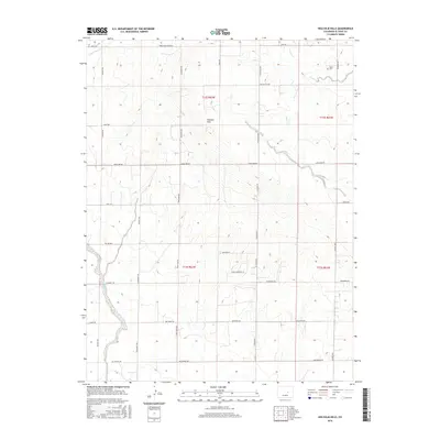
2016 Map of Holcolm Hills
USGS Topo · Published 2016About this map
Holcolm Hills dominates the central landscape of this El Paso County quadrant, where the high plains of eastern Colorado are carved by several drainage systems. The northern reaches are defined by the presence of Myers Cem near Horse Cr, while the winding course of Steels Fork cuts through the center of the survey. The regional transport network is anchored by a grid of rural routes such as N Calhan Hwy and Falcon Hwy, facilitating access across the various cattle and ranching divisions. Industrial activity is noted in the north at the Robin Brick Company, while residential or property landmarks like Highland Ranch Pt and Wilkerson Vw suggest the evolving land use of the early 21st century. The map provides a clear view of the intersection between established family landmarks and the natural topography of Brackett Cr.
Find a feature on this map
38 named features on this map. Tap any name to fly to it.
Don’t see what you’re looking for? This feature index may not catch every label — zoom into the map to look around manually.
Map Details
Editions of this 2016 Holcolm Hills Map
This is the sole edition of this map. No revisions or reprints were ever made.
Other maps of this area

1893 · Big Springs
USGS Topo · 1:125,000

1953 · Denver
USGS Topo · 1:250,000
1954 · Ellicott
USGS Topo · 1:24,000
1954 · Haegler Ranch
USGS Topo · 1:24,000

1954 · Pueblo
USGS Topo · 1:250,000

1957 · Denver
USGS Topo · 1:250,000

1957 · Pueblo
USGS Topo · 1:250,000

1958 · Pueblo
USGS Topo · 1:250,000

1958 · Denver
USGS Topo · 1:250,000

1960 · Denver
USGS Topo · 1:250,000