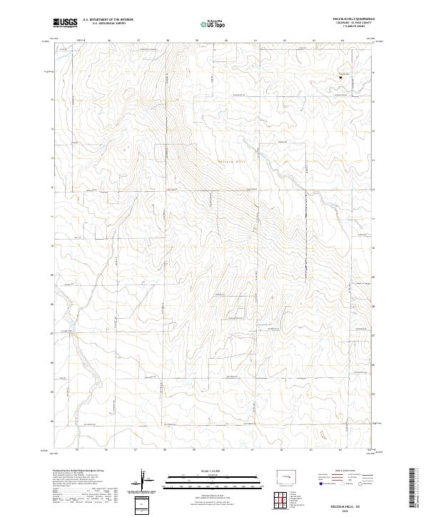
2022 Map of Holcolm Hills
USGS Topo · Published 2022About this map
Holcolm Hills rises as the central geographic feature of this El Paso County landscape, where the high plains transition into a network of seasonal drainages. The area is defined by a grid of rural roads and ranching tracks, with water features like Steels Fork, Horse Cr, and Brackett Cr carving subtle relief into the terrain. One of the few indicators of historical settlement and local lineage is the Myers Cem located in the northeast, offering a specific point of interest for genealogists tracing early families in the region. Evidence of local industry appears in the northwest corner near the Robin Brick Company, while the survey also details modern land use through labels like Highland Ranch Pt. The transportation network relies on major connectors such as N Calhan Hwy and Falcon Hwy, which tie these remote ranch lands to the broader county infrastructure.
Find a feature on this map
42 named features on this map. Tap any name to fly to it.
Don’t see what you’re looking for? This feature index may not catch every label — zoom into the map to look around manually.
Map Details
Editions of this 2022 Holcolm Hills Map
This is the sole edition of this map. No revisions or reprints were ever made.
Other maps of this area

1893 · Big Springs
USGS Topo · 1:125,000

1953 · Denver
USGS Topo · 1:250,000
1954 · Ellicott
USGS Topo · 1:24,000
1954 · Haegler Ranch
USGS Topo · 1:24,000

1954 · Pueblo
USGS Topo · 1:250,000

1957 · Denver
USGS Topo · 1:250,000

1957 · Pueblo
USGS Topo · 1:250,000

1958 · Pueblo
USGS Topo · 1:250,000

1958 · Denver
USGS Topo · 1:250,000

1960 · Denver
USGS Topo · 1:250,000