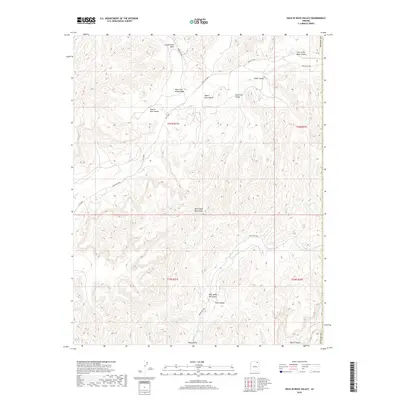
2018 Map of Hole In Rock Valley
USGS Topo · Published 2018About this map
Hole in Rock Valley and the surrounding high desert of the Chinle Agency are defined by a complex network of seasonal drainage and named valleys within the Navajo Nation. This 2018 survey reveals a landscape etched with evocative toponyms like Pain in the Back Canyon and Devils Canyon, reflecting the challenging terrain encountered by those navigating the region. The map documents the vital corridors of the West Fork Oraibi Wash and Wepo Wash, which serve as the primary conduits for moisture across this arid geography. Transportation is limited to high-clearance routes such as Indian Rte 8066 and Indian Rte 8030, which follow the contours between elevations like West Steep Hill Valley and East Steep Hill Valley. The scarcity of permanent structures highlights the land's primary use for open-range grazing and seasonal movement.
Find a feature on this map
24 named features on this map. Tap any name to fly to it.
Don’t see what you’re looking for? This feature index may not catch every label — zoom into the map to look around manually.
Map Details
Editions of this 2018 Hole In Rock Valley Map
This is the sole edition of this map. No revisions or reprints were ever made.
Other maps of this area

1883 · Marsh Pass
USGS Topo · 1:250,000

1892 · Marsh Pass
USGS Topo · 1:250,000

1892 · Canyon De Chelly
USGS Topo · 1:250,000

1954 · Shiprock
USGS Topo · 1:250,000

1956 · Marble Canyon
USGS Topo · 1:250,000

1958 · Shiprock
USGS Topo · 1:250,000

1959 · Shiprock
USGS Topo · 1:250,000

1959 · Marble Canyon
USGS Topo · 1:250,000

1961 · Marble Canyon
USGS Topo · 1:250,000
1967 · Pinon NW
USGS Topo · 1:24,000