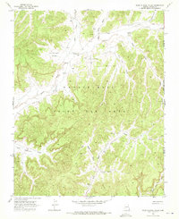
1968 Map of Hole In Rock Valley
USGS Topo · Published 1971About this map
Kitsillie Chapter House serves as a primary cultural anchor in this high-desert landscape, situated near the headwaters of Aspen Grove Wash. Surveyed in the late 1960s, the terrain is defined by a complex network of seasonal drainages including Oraibi Wash, Wepo Wash, and West Fork Celebration Wash. These washes carve deep through the plateau, forming named corridors like Hole in Rock Valley and the descriptively titled West Steep Hill Valley and East Steep Hill Valley.
Find a feature on this map
19 named features on this map. Tap any name to fly to it.
Don’t see what you’re looking for? This feature index may not catch every label — zoom into the map to look around manually.
Map Details
Editions of this 1968 Hole In Rock Valley Map
This is the sole edition of this map. No revisions or reprints were ever made.
Other maps of this area

1883 · Marsh Pass
USGS Topo · 1:250,000

1892 · Marsh Pass
USGS Topo · 1:250,000

1892 · Canyon De Chelly
USGS Topo · 1:250,000

1954 · Shiprock
USGS Topo · 1:250,000

1956 · Marble Canyon
USGS Topo · 1:250,000

1958 · Shiprock
USGS Topo · 1:250,000

1959 · Shiprock
USGS Topo · 1:250,000

1959 · Marble Canyon
USGS Topo · 1:250,000

1961 · Marble Canyon
USGS Topo · 1:250,000
1967 · Pinon NW
USGS Topo · 1:24,000