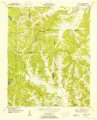
1950 Map of Holladay
USGS Topo · Published 1953About this map
The boundary lines of Carroll, Benton, Decatur, and Henderson counties converge in this rural landscape as it appeared in the early 1950s. Much of the western terrain is occupied by the Natchez Trace State Park and Forest, featuring the Maple Creek Lookout Tower and the Pecan Tree Picnic and Camp Ground. The settlement of Holladay serves as a primary hub in the northeast, while Shiloh sits further south near the Carroll and Benton line.
Find a feature on this map
60 named features on this map. Tap any name to fly to it.
Don’t see what you’re looking for? This feature index may not catch every label — zoom into the map to look around manually.
Map Details
Editions of this 1950 Holladay Map
3 editions found
Other maps of this area

1936 · Yuma
USGS Topo · 1:24,000

1936 · Parsons
USGS Topo · 1:24,000

1936 · Seventeen Creek
USGS Topo · 1:24,000

1936 · Jeannette
USGS Topo · 1:24,000

1936 · Sugar Tree
USGS Topo · 1:24,000

1936 · Cavvia
USGS Topo · 1:24,000

1936 · Buena Vista
USGS Topo · 1:24,000

1936 · Rockport
USGS Topo · 1:24,000

1936 · Chesterfield
USGS Topo · 1:24,000
1949 · Jeannette
USGS Topo · 1:24,000