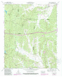
1950 Map of Holladay
USGS Topo · Published 1988About this map
Natchez Trace State Forest dominates the western landscape of this mid-century survey, where the Maple Creek Lookout Tower stands over a network of hollows and ridges. The settlement of Holladay serves as a northern anchor, while the surrounding countryside is defined by family-named landmarks and rural congregations like Franks Chapel and New Prospect Ch. This area, where several counties meet, shows a dense distribution of small cemeteries including Holladay Cem, Shiloh Cem, and Morgan Cem, suggesting deep genealogical roots in the Tennessee uplands. The drainage pattern is complex, with West Fork Birdsong Creek and the many branches of Cub Creek carving through the terrain. Evidence of later modernization appears in the purple revisions, which include the path of an interstate and Interchange 116 cutting across the central ridges.
Find a feature on this map
58 named features on this map. Tap any name to fly to it.
Don’t see what you’re looking for? This feature index may not catch every label — zoom into the map to look around manually.
Map Details
Editions of this 1950 Holladay Map
3 editions found
Other maps of this area

1936 · Yuma
USGS Topo · 1:24,000

1936 · Parsons
USGS Topo · 1:24,000

1936 · Seventeen Creek
USGS Topo · 1:24,000

1936 · Jeannette
USGS Topo · 1:24,000

1936 · Sugar Tree
USGS Topo · 1:24,000

1936 · Cavvia
USGS Topo · 1:24,000

1936 · Buena Vista
USGS Topo · 1:24,000

1936 · Rockport
USGS Topo · 1:24,000

1936 · Chesterfield
USGS Topo · 1:24,000
1949 · Jeannette
USGS Topo · 1:24,000