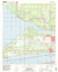
1994 Map of Holley
USGS Topo · Published 1999About this map
Santa Rosa Sound and the Intracoastal Waterway define the southern corridor of this coastal Florida landscape, where development is tightly bounded by significant military holdings and protected lands. To the north, Eglin Air Force Base occupies a vast tract of interior woodland, complemented by specialized aviation sites like Holley Field (Air Force OLF) and Choctaw (Navy OLF). This juxtaposition of military utility and natural preservation is most evident along the southern shore, where the Gulf Islands National Seashore protects Santa Rosa Island and its Sand Dunes.
Find a feature on this map
36 named features on this map. Tap any name to fly to it.
Don’t see what you’re looking for? This feature index may not catch every label — zoom into the map to look around manually.
Map Details
Editions of this 1994 Holley Map
This is the sole edition of this map. No revisions or reprints were ever made.
Other maps of this area

1920 · Milton
USGS Topo · 1:62,500

1921 · Holley
USGS Topo · 1:62,500

1921 · Pensacola
USGS Topo · 1:62,500

1934 · Harold
USGS Topo · 1:62,500

1936 · Holley
USGS Topo · 1:48,000

1937 · Harold
USGS Topo · 1:62,500

1938 · Holley
USGS Topo · 1:62,500

1938 · Harold
USGS Topo · 1:62,500

1941 · Pensacola
USGS Topo · 1:62,500

1941 · Milton
USGS Topo · 1:62,500