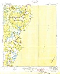
1944 Map of Hollingers Island
USGS Topo · Published 1944About this map
Hollingers Island and the coastal marshes of the western Mobile Bay shoreline are captured here as they appeared just before the mid-century. This coastal landscape is defined by the winding course of the Dog River, where social and recreational landmarks like the Gulf Hunting and Fishing Club and Mobile Yacht Club suggest a well-established waterfront culture. Further inland, the presence of the G M & O RR (Abandoned) line traces the evolution of transportation in the Mobile area, showing how rail was already giving way to the road network including Cedar Point Road and Riverside Drive. Local life centers on small rural institutions such as the Racetrack Sch and New Hope Ch, while the Gaillard Cem provides a specific point of interest for those tracing family genealogy in this part of Alabama.
Find a feature on this map
22 named features on this map. Tap any name to fly to it.
Don’t see what you’re looking for? This feature index may not catch every label — zoom into the map to look around manually.
Map Details
Editions of this 1944 Hollingers Island Map
2 editions found
Other maps of this area

1921 · Point Clear
USGS Topo · 1:62,500

1921 · Fairhope
USGS Topo · 1:62,500

1921 · Delchamps
USGS Topo · 1:62,500

1922 · Mobile
USGS Topo · 1:62,500

1939 · Daphne
USGS Topo · 1:31,680

1940 · Hollingers Island
USGS Topo · 1:31,680

1940 · Mobile
USGS Topo · 1:31,680

1940 · Mobile
USGS Topo · 1:62,500

1941 · Daphne
USGS Topo · 1:31,680

1941 · Cedar Point
USGS Topo · 1:62,500