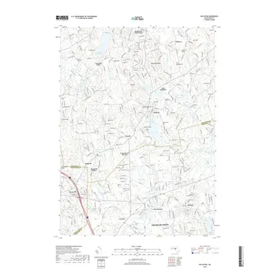
2018 Map of Holliston
USGS Topo · Published 2018About this map
Holliston and Medway center this 2018 topographic study, where the developed corridors of Norfolk and Middlesex counties meet a landscape still defined by its complex glacial hydrology. Waterways like the Charles River, Bogastow Brook, and Hopping Brook thread through extensive wetlands, including the Great Black Swamp and Dirty Meadow Swamp. The map highlights a long history of settlement and community life, marked by numerous burial grounds such as Oakland Cem, Bragg Cem, and the West Burying Ground. Transportation patterns are anchored by Interstate 495 and the historic footprint of the Braggville Station, reflecting the area's evolution from a cluster of villages like Gooch Corners and Metcalf into a modern residential and light industrial region. Significant recreational and topographic features, from Lake Winthrop and its Pleasure Point to the elevations of Mt Hollis and Bare Hill, illustrate the varied terrain that has shaped the growth of East Holliston and West Medway.
Find a feature on this map
78 named features on this map. Tap any name to fly to it.
Don’t see what you’re looking for? This feature index may not catch every label — zoom into the map to look around manually.
Map Details
Editions of this 2018 Holliston Map
This is the sole edition of this map. No revisions or reprints were ever made.
Other maps of this area

1886 · Blackstone
USGS Topo · 1:62,500

1886 · Framingham
USGS Topo · 1:62,500

1887 · Franklin
USGS Topo · 1:62,500

1887 · Marlboro
USGS Topo · 1:62,500

1889 · Marlboro
USGS Topo · 1:62,500

1889 · Blackstone
USGS Topo · 1:62,500

1889 · Franklin
USGS Topo · 1:62,500

1889 · Framingham
USGS Topo · 1:62,500

1893 · Franklin
USGS Topo · 1:62,500

1893 · Blackstone
USGS Topo · 1:62,500