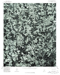
1975 Map of Holly Pond
USGS Topo · Published 1977About this map
Holly Pond is the primary settlement on this orthophotoquad, which reveals the intricate agricultural landscape of Cullman County during the mid-1970s. This specific type of survey, produced in cooperation with the Soil Conservation Service, uses a December 1975 aerial photograph to provide a detailed visual record of land use rather than traditional topographic contours. The resulting image showcases the dense patchwork of cleared fields and wooded drainage patterns that define the region. Further north, the small community of Brooklyn sits amidst this rural terrain, providing a clear view of the road networks and farmstead placements as they existed before modern development altered the footprint of these North Alabama communities.
Find a feature on this map
2 named features on this map. Tap any name to fly to it.
Don’t see what you’re looking for? This feature index may not catch every label — zoom into the map to look around manually.
Map Details
Editions of this 1975 Holly Pond Map
This is the sole edition of this map. No revisions or reprints were ever made.
Other maps of this area

1885 · Gadsden
USGS Topo · 1:125,000

1888 · Cullman
USGS Topo · 1:125,000

1888 · Gadsden
USGS Topo · 1:125,000

1892 · Cullman
USGS Topo · 1:125,000

1892 · Gadsden
USGS Topo · 1:125,000

1895 · Gadsden
USGS Topo · 1:125,000

1903 · Gadsden
USGS Topo · 1:125,000

1936 · Hulaco
USGS Topo · 1:24,000

1936 · Arab
USGS Topo · 1:24,000

1936 · Lawrence Cove
USGS Topo · 1:24,000