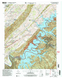
2003 Map of Holston Valley
USGS Topo · Published 2004About this map
South Holston Lake dominates the central landscape of this survey, its complex shoreline winding through the ridges and hollows of the Cherokee National Forest. The massive South Holston Dam stands at the lake's western edge, accompanied by specialized infrastructure like the Sluiceway Control Tower and Overflow Spillway. The terrain is defined by the steep, parallel ridges of The Knobs and McConnell Ridge, which separate the river valley from the growing outskirts of Bristol and Goose Pimple Junction.
Find a feature on this map
70 named features on this map. Tap any name to fly to it.
Don’t see what you’re looking for? This feature index may not catch every label — zoom into the map to look around manually.
Map Details
Editions of this 2003 Holston Valley Map
This is the sole edition of this map. No revisions or reprints were ever made.
Other maps of this area

1891 · Roan Mountain
USGS Topo · 1:125,000

1891 · Abingdon
USGS Topo · 1:125,000

1893 · Cranberry
USGS Topo · 1:125,000

1894 · Roan Mountain
USGS Topo · 1:125,000

1894 · Abingdon
USGS Topo · 1:125,000

1895 · Cranberry
USGS Topo · 1:125,000

1897 · Bristol
USGS Topo · 1:125,000

1899 · Cranberry
USGS Topo · 1:125,000

1902 · Bristol
USGS Topo · 1:125,000

1902 · Cranberry
USGS Topo · 1:125,000