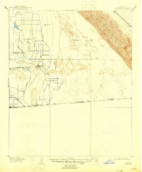
1907 Map of Holtville
USGS Topo · Published 1946About this map
Holtville and the burgeoning irrigation systems of the Imperial Valley dominate this landscape at the dawn of the twentieth century. Surveyed by the U.S. Reclamation Service in 1905, the map documents an engineered agricultural environment where names like the Peach Ditch, Plum Ditch, and Pomelo Ditch hint at the specific citrus and stone fruit groves then taking root in the desert. The Alamo River flows through a basin that drops to 100 feet below sea level, creating a stark contrast with the massive Sand Hills rising to the east.
Find a feature on this map
39 named features on this map. Tap any name to fly to it.
Don’t see what you’re looking for? This feature index may not catch every label — zoom into the map to look around manually.
Map Details
Editions of this 1907 Holtville Map
4 editions found
Other maps of this area

1903 · Yuma
USGS Topo · 1:125,000

1905 · Yuma
USGS Topo · 1:125,000

1907 · Holtville
USGS Topo · 1:125,000

1915 · El Centro
USGS Topo · 1:125,000

1940 · Brawley
USGS Topo · 1:62,500

1940 · Iris
USGS Topo · 1:62,500

1940 · Heber
USGS Topo · 1:62,500

1940 · Alamorio
USGS Topo · 1:62,500

1940 · Calexico
USGS Topo · 1:62,500

1942 · El Centro
USGS Topo · 1:250,000