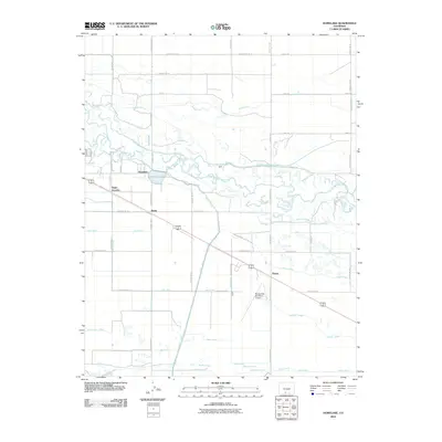
2010 Map of Homelake
USGS Topo · Published 2010About this map
The Rio Grande meanders across this San Luis Valley landscape, defining a complex network of agricultural irrigation in Rio Grande County. By the early 21st century, the region around the settlement of Homelake shows a highly developed system of water management, visible through major arteries like the San Luis Valley Canal and the Empire Canal. These waterways, alongside smaller features like the Billings Ditch and Centennial Ditch, illustrate the vital role of water rights and engineering in this high-altitude valley. Small junctions and loading points such as Sugar Junction, Zinzer, and Parma dot the landscape along the road and rail corridors, reflecting the area's agricultural shipping history. Landmarks like Sherman Lake and the Monte Vista Municipal Airport provide clear orientation points within this grid of county roads and drainage laterals, including the Parma Drain and McLean Drain.
Find a feature on this map
54 named features on this map. Tap any name to fly to it.
Don’t see what you’re looking for? This feature index may not catch every label — zoom into the map to look around manually.
Map Details
Editions of this 2010 Homelake Map
This is the sole edition of this map. No revisions or reprints were ever made.
Other maps of this area

1915 · Del Norte
USGS Topo · 1:125,000

1917 · Del Norte
USGS Topo · 1:125,000

1922 · Conejos
USGS Topo · 1:125,000

1945 · Durango
USGS Topo · 1:250,000

1953 · Durango
USGS Topo · 1:250,000

1954 · Durango
USGS Topo · 1:250,000

1954 · Trinidad
USGS Topo · 1:250,000

1955 · Trinidad
USGS Topo · 1:250,000

1958 · Trinidad
USGS Topo · 1:250,000

1959 · Trinidad
USGS Topo · 1:250,000