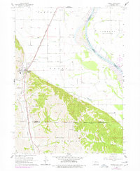
1964 Map of Homer
USGS Topo · Published 1977About this map
Homer serves as the primary settlement on this landscape, positioned where the hills meet the flat agricultural bottoms of the Missouri River valley. The Chicago Burlington and Quincy railroad runs parallel to Omaha Creek, tracing the base of the bluffs and connecting local agriculture to wider markets. The southern portion of the map is defined by the Winnebago Indian Reservation Boundary, cutting across a topography of dissected ridges and small watercourses like Honey Creek and Big Bear Creek.
Find a feature on this map
29 named features on this map. Tap any name to fly to it.
Don’t see what you’re looking for? This feature index may not catch every label — zoom into the map to look around manually.
Map Details
Editions of this 1964 Homer Map
2 editions found
Other maps of this area

1955 · Sioux City
USGS Topo · 1:250,000

1958 · Sioux City
USGS Topo · 1:250,000

1959 · Sioux City
USGS Topo · 1:250,000

1963 · Sioux City South
USGS Topo · 1:24,000

1964 · Sergeant Bluff
USGS Topo · 1:24,000

1964 · Homer
USGS Topo · 1:24,000

1964 · Salix
USGS Topo · 1:24,000

1966 · Walthill
USGS Topo · 1:24,000

1966 · Pender NE
USGS Topo · 1:24,000
1967 · Jackson
USGS Topo · 1:24,000