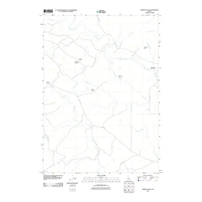
2010 Map of Homer Valley
USGS Topo · Published 2010About this map
Homer Valley and its surrounding drainage systems define this high-altitude landscape in Bonneville County. The intricate path of Grays Lake Outlet meanders across the terrain, joined by numerous tributaries including Homer Creek, Brockman Creek, and Duckworth Creek. This map reveals a pocket of Idaho backcountry organized around seasonal waterways and topographic landmarks like Sugarloaf Mountain and the uniquely named Particular Knoll.
Find a feature on this map
21 named features on this map. Tap any name to fly to it.
Don’t see what you’re looking for? This feature index may not catch every label — zoom into the map to look around manually.
Map Details
Editions of this 2010 Homer Valley Map
This is the sole edition of this map. No revisions or reprints were ever made.
Other maps of this area

1917 · Cranes Flat
USGS Topo · 1:62,500

1924 · Hell Creek
USGS Topo · 1:62,500

1926 · Hell Creek
USGS Topo · 1:62,500

1932 · Irwin
USGS Topo · 1:96,000

1935 · Irwin
USGS Topo · 1:125,000

1955 · Driggs
USGS Topo · 1:250,000

1958 · Driggs
USGS Topo · 1:250,000

1962 · Driggs
USGS Topo · 1:250,000
1966 · Bear Island
USGS Topo · 1:24,000
1966 · Herman
USGS Topo · 1:24,000