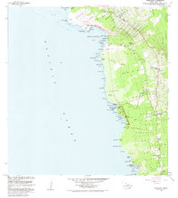
1982 Map of Honaunau
USGS Topo · Published 1982About this map
Puuhonua O Honaunau National Historical Park anchors this coastal survey of the South Kona District, preserving ancient Hawaiian sanctuaries like the Hale o Keawe Heiau and Alealea Heiau. The shoreline is a dense record of indigenous and colonial interaction, from the Cooks Monument at Kealakekua Bay to the village at Napoopoo. The landscape rising toward the Honapnau Forest Reserve reflects the local agrarian economy of the early 1980s, specifically the coffee industry centered around the Coffee Mill near Captain Cook. Local social life is mapped through sites like the Honaunau Rodeo Arena and multiple rural educational centers, including Napoopoo School and Honaunau School. Along the coast, numerous points such as Palemano Pt and Miana Pt separate small bays and coves, including Keoneele Cove and Kiilae Bay, where traditional heiau ruins like Omao Heiau still stand.
Find a feature on this map
89 named features on this map. Tap any name to fly to it.
Don’t see what you’re looking for? This feature index may not catch every label — zoom into the map to look around manually.
Map Details
Editions of this 1982 Honaunau Map
2 editions found
Other maps of this area

1928 · Kailua
USGS Topo · 1:62,500

1954 · Hawaii South
USGS Topo · 1:250,000

1954 · Hawaii North
USGS Topo · 1:250,000

1959 · Hawaii South
USGS Topo · 1:250,000

1959 · Hawaii North
USGS Topo · 1:250,000

1959 · Honaunau
USGS Topo · 1:24,000

1959 · Puu Lehua
USGS Topo · 1:24,000
1960 · Kaunene
USGS Topo · 1:24,000
1960 · Kealakekua
USGS Topo · 1:24,000

1961 · Hawaii North
USGS Topo · 1:250,000