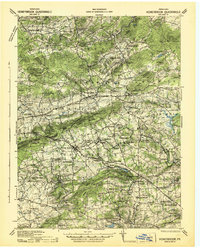
1941 Map of Honeybrook
USGS Topo · Published 1941About this map
Welsh Mountain forms a prominent ridge across this 1941 survey, separating the drainage basins of the Conestoga Creek and the Pequea Creek as they flow through the fertile valleys of Lancaster and Chester Counties. The map documents a rural landscape in transition, where established farm-to-market settlements like Honey Brook, Morgantown, and Elverson are linked by the newly constructed Pennsylvania Turnpike.
Find a feature on this map
97 named features on this map. Tap any name to fly to it.
Don’t see what you’re looking for? This feature index may not catch every label — zoom into the map to look around manually.
Map Details
Editions of this 1941 Honeybrook Map
This is the sole edition of this map. No revisions or reprints were ever made.
Other maps of this area

1894 · Reading
USGS Topo · 1:62,500

1901 · West Chester
USGS Topo · 1:62,500

1902 · Boyertown
USGS Topo · 1:62,500

1902 · Wernersville
USGS Topo · 1:62,500

1904 · West Chester
USGS Topo · 1:62,500

1904 · Coatesville
USGS Topo · 1:62,500

1905 · Honey Brook
USGS Topo · 1:62,500
1906 · Phoenixville
USGS Topo · 1:62,500

1906 · Coatesville
USGS Topo · 1:62,500

1906 · New Holland
USGS Topo · 1:62,500