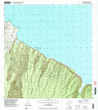
1993 Map of Honokane
USGS Topo · Published 2003About this map
Niuli'i and Makapala anchor the northwestern coastline of this North Kohala landscape, where small settlements give way to a dramatic series of deep coastal valleys. The terrain is defined by the massive erosional features of the Kohala Forest Reserve, including the expansive Pololu Valley and Waimanu Valley. Water management and transport are evident through infrastructure like the Awini Weir and the remote Waimanu Trail, which navigates the steep gulches and ridges between Waimanu Bay and the interior.
Find a feature on this map
68 named features on this map. Tap any name to fly to it.
Don’t see what you’re looking for? This feature index may not catch every label — zoom into the map to look around manually.
Map Details
Editions of this 1993 Honokane Map
This is the sole edition of this map. No revisions or reprints were ever made.
Other maps of this area

1913 · Kohala
USGS Topo · 1:62,500

1916 · Kohala
USGS Topo · 1:62,500

1916 · Waipio
USGS Topo · 1:62,500

1954 · Hawaii North
USGS Topo · 1:250,000

1956 · Kamuela
USGS Topo · 1:24,000

1956 · Kawaihae
USGS Topo · 1:24,000
1957 · Honokane
USGS Topo · 1:24,000
1957 · Hawi
USGS Topo · 1:24,000

1959 · Hawaii North
USGS Topo · 1:250,000

1961 · Hawaii North
USGS Topo · 1:250,000