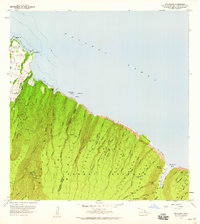
1957 Map of Honokane
USGS Topo · Published 1959About this map
Kohala Forest Reserve dominates this 1957 landscape, where the steep, verdant ridges of the North Kohala District meet the Pacific. The complex hydraulic engineering of the era is evident in the trace of the Kohala Ditch and Kehena Ditch, alongside features like the Awini Weir and several gaging stations. These systems moved water across the difficult terrain of Honokane Nui and Honokane Iki to support downstream industries. Near the coast, small settlements like Niulii and Waiapuka sit above the sea cliffs, while the interior is marked by surveying history at Old USGS Camp and New USGS Camp. The map provides detailed coastal context, identifying coral reefs and dramatic points such as Kaialae Pt, alongside the isolated Waimanu Valley and the spectacular Waiilikahi Falls.
Find a feature on this map
41 named features on this map. Tap any name to fly to it.
Don’t see what you’re looking for? This feature index may not catch every label — zoom into the map to look around manually.
Map Details
Editions of this 1957 Honokane Map
2 editions found
Other maps of this area

1913 · Kohala
USGS Topo · 1:62,500

1916 · Kohala
USGS Topo · 1:62,500

1916 · Waipio
USGS Topo · 1:62,500

1954 · Hawaii North
USGS Topo · 1:250,000

1956 · Kamuela
USGS Topo · 1:24,000

1956 · Kawaihae
USGS Topo · 1:24,000
1957 · Hawi
USGS Topo · 1:24,000

1959 · Hawaii North
USGS Topo · 1:250,000

1961 · Hawaii North
USGS Topo · 1:250,000

1975 · Hawaii
USGS Topo · 1:250,000