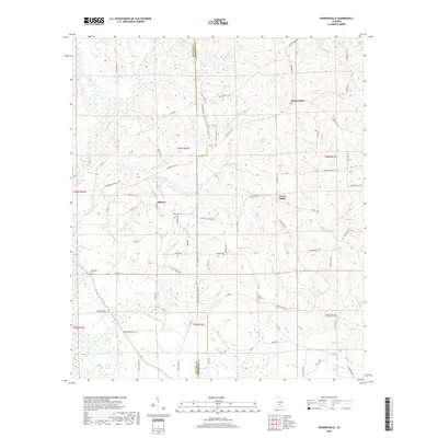
2018 Map of Honoraville
USGS Topo · Published 2018About this map
Honoraville serves as a focal point in this section of the Alabama coastal plain, situated near the intersection of several county roads and the drainage of Horse Creek. The landscape is defined by an intricate network of tributaries and small impoundments, including Lake Jane, Ropers Pond, and Masseys Pond, which feed into larger systems like Pigeon Creek and its associated Pigeon Creek Swamp. Small rural communities such as Midway and Center Ridge are linked by a grid of named local routes, including Pollard Road and Raybon Road, reflecting the area's agricultural and timber-based layout. Genealogy researchers will find several localized landmarks of interest, particularly the Damascus Cemetery in the west and Black Rock Cemetery to the southeast, along with family-named drainages like Skipper Mill Br and Graydon Branch that suggest early landholdings and community centers across the Butler and Crenshaw county line.
Find a feature on this map
87 named features on this map. Tap any name to fly to it.
Don’t see what you’re looking for? This feature index may not catch every label — zoom into the map to look around manually.
Map Details
Editions of this 2018 Honoraville Map
This is the sole edition of this map. No revisions or reprints were ever made.
Other maps of this area

1953 · Andalusia
USGS Topo · 1:250,000

1957 · Andalusia
USGS Topo · 1:250,000

1971 · Luverne
USGS Topo · 1:24,000

1971 · Fullers Crossroads
USGS Topo · 1:24,000

1971 · Pigeon Creek
USGS Topo · 1:24,000

1971 · Fort Deposit
USGS Topo · 1:24,000

1971 · Honoraville
USGS Topo · 1:24,000

1971 · Moodys Crossroads
USGS Topo · 1:24,000

1971 · Greenville East
USGS Topo · 1:24,000

1971 · Danielsville
USGS Topo · 1:24,000