
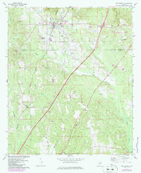
1971 Map of Fort Deposit
USGS Topo · Published 1973About this map
Fort Deposit serves as the primary hub in this portion of south Alabama, situated at the headwaters of numerous creeks including Mussel Creek and Ballards Creek. The town is well-documented with civic infrastructure such as the Armory, High Sch, and an Athletic Field, alongside several historic burial grounds like Myrtlewood Cem and Jordan Cem. Beyond the town limits, the landscape transitions into the Gilmer Hills and Barganier Hill, where industry and rural life intersect. Evidence of extraction appears south of town at the Strip Mines, while the Louisville And Nashville railroad provides the backbone for local transit. The map records several smaller communities and landmarks, such as Searey and Spring Hill, and a significant density of country churches including Macedonia Ch and Hopewell Ch that define the social geography of the Lowndes Co and Butler Co borderlands.
Find a feature on this map
36 named features on this map. Tap any name to fly to it.
Don’t see what you’re looking for? This feature index may not catch every label — zoom into the map to look around manually.
Map Details
Editions of this 1971 Fort Deposit Map
2 editions found
Other maps of this area

1953 · Montgomery
USGS Topo · 1:250,000

1953 · Andalusia
USGS Topo · 1:250,000

1956 · Montgomery
USGS Topo · 1:250,000

1957 · Montgomery
USGS Topo · 1:250,000

1957 · Andalusia
USGS Topo · 1:250,000

1957 · Letohatchee
USGS Topo · 1:62,500

1971 · Greenville West
USGS Topo · 1:24,000

1971 · Honoraville
USGS Topo · 1:24,000

1971 · Fort Dale
USGS Topo · 1:24,000

1971 · Greenville East
USGS Topo · 1:24,000