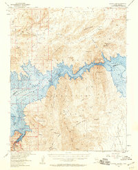
1953 Map of Hoover Dam
USGS Topo · Published 1959About this map
Hoover Dam anchors this mid-century study of the border between Nevada and Arizona, where the impounded Colorado River fills the jagged basins of the Lake Mead National Recreational Area. The map reveals the dramatic intersection of desert geology and massive human engineering, featuring the flooded contours of Boulder Canyon and the expansive Lake Mead. Beyond the water's edge, the landscape is marked by the complex topography of the Pinto Valley and Bitter Spring Valley, interspersed with evidence of early twentieth-century desert life and extraction. Scattered landmarks like Old Pop's Mine and the Cofhenour Mine speak to the region's mining history, while Bonnelli Landing Road provides a rare terrestrial path through the rugged terrain east of Hamblin Bay. This edition is particularly notable for its inclusion of underwater contours, illustrating the submerged canyon floor as it existed after the dam's completion.
Find a feature on this map
40 named features on this map. Tap any name to fly to it.
Don’t see what you’re looking for? This feature index may not catch every label — zoom into the map to look around manually.
Map Details
Editions of this 1953 Hoover Dam Map
3 editions found

Other maps of this area

1886 · Camp Mohave
USGS Topo · 1:250,000

1886 · Saint Thomas
USGS Topo · 1:250,000

1892 · Camp Mohave
USGS Topo · 1:250,000

1893 · Saint Thomas
USGS Topo · 1:250,000

1926 · Nelson
USGS Topo · 1:96,000

1926 · Bonelli
USGS Topo · 1:96,000

1926 · Boulder Canyon
USGS Topo · 1:96,000

1942 · Camp Mohave
USGS Topo · 1:250,000

1947 · Kingman
USGS Topo · 1:250,000

1948 · Kingman
USGS Topo · 1:250,000