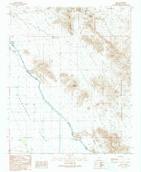
1990 Map of Hope
USGS Topo · Published 1990About this map
Granite Wash Mountains and the Harquahala Mountains frame this arid landscape, where the Hayden-Rhodes Aqueduct cuts a definitive line across the Ran Egra S Plain. This 1990 provisional map documents the industrial and water-management infrastructure vital to the desert, including a series of flumes, siphons, and a Road on Levee tracking the aqueduct's path. The small settlement of Hope sits near the northern boundary, serving as a rare point of habitation in a region otherwise defined by resource extraction and rugged terrain. Mining activity is evident through numerous prospects and the Blackcat Mine located near Granite Wash Pass. The presence of several wells and a Check Dam highlight the critical nature of water management in this part of Mc Mullen Valley, while Bouse Wash marks the natural drainage patterns of the desert floor.
Find a feature on this map
23 named features on this map. Tap any name to fly to it.
Don’t see what you’re looking for? This feature index may not catch every label — zoom into the map to look around manually.
Map Details
Editions of this 1990 Hope Map
This is the sole edition of this map. No revisions or reprints were ever made.
Other maps of this area

1942 · Vicksburg
USGS Topo · 1:250,000

1954 · Phoenix
USGS Topo · 1:250,000

1957 · Phoenix
USGS Topo · 1:250,000

1958 · Phoenix
USGS Topo · 1:250,000

1960 · Phoenix
USGS Topo · 1:250,000

1961 · Salome
USGS Topo · 1:62,500

1961 · Hope
USGS Topo · 1:62,500
1962 · Utting
USGS Topo · 1:62,500

1962 · Vicksburg
USGS Topo · 1:62,500

1969 · Phoenix
USGS Topo · 1:250,000