
1916 Map of Hopeton
USGS Topo · Published 1916About this map
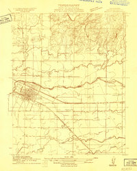
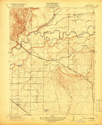
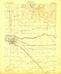
The Merced River winds through this Central Valley landscape, defining the agricultural and transit corridors of the early twentieth century. Irrigation infrastructure is prominent, with the Crocker Hoffman Canal and various other unlabelled canals branching across the terrain to support the region's development. Near the southern edge, Yosemite Lake serves as a major water feature, while the small settlement of Hopeton sits in the northwest near the river's bend.
Find a feature on this map
11 named features on this map. Tap any name to fly to it.
Don’t see what you’re looking for? This feature index may not catch every label — zoom into the map to look around manually.
Map Details
Editions of this 1916 Hopeton Map
This is the sole edition of this map. No revisions or reprints were ever made.
Other maps of this area

1893 · Sonora
USGS Topo · 1:125,000

1896 · Sonora
USGS Topo · 1:125,000

1897 · Sonora
USGS Topo · 1:125,000

1898 · Sonora
USGS Topo · 1:125,000

1913 · Dickenson
USGS Topo · 1:31,680
1914 · Merced
USGS Topo · 1:31,680

1916 · Three Tree Flat
USGS Topo · 1:31,680

1916 · Merced Falls
USGS Topo · 1:24,000
1917 · Winton
USGS Topo · 1:31,680
1917 · Merced
USGS Topo · 1:31,680