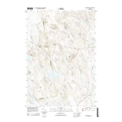
2014 Map of Hopkins Pond
USGS Topo · Published 2014About this map
Hopkins Pond and the surrounding woodlands of eastern Maine define this landscape, where the boundary between Penobscot and Hancock counties cuts through the interior. The terrain is marked by prominent elevations such as Chick Hill, Saddleback Mtn, and Peaked Mtn, providing a look at the glaciated topography that shapes the local watershed. Historically, the area is connected by the Airline Rd, a significant corridor that passes through the settlement at Archers Corners. Water features dominate the southern and eastern portions of the map, including the West Branch Union River as it flows toward Graham Lake. Local genealogy and land use are evidenced by several small burying grounds, including Amherst Cem, Hadley Cem, and Frost Cem, along with landmarks like Twin Bridges and Goodwin Bridge which facilitate movement across the river and brooks.
Find a feature on this map
75 named features on this map. Tap any name to fly to it.
Don’t see what you’re looking for? This feature index may not catch every label — zoom into the map to look around manually.
Map Details
Editions of this 2014 Hopkins Pond Map
This is the sole edition of this map. No revisions or reprints were ever made.
Other maps of this area

1900 · Orland
USGS Topo · 1:62,500

1902 · Orono
USGS Topo · 1:62,500

1911 · Ellsworth
USGS Topo · 1:62,500

1929 · Great Pond
USGS Topo · 1:48,000

1932 · Great Pond
USGS Topo · 1:62,500

1940 · Ellsworth
USGS Topo · 1:62,500

1942 · Orland
USGS Topo · 1:62,500

1942 · Ellsworth
USGS Topo · 1:62,500

1944 · Orono
USGS Topo · 1:62,500

1946 · Orono
USGS Topo · 1:62,500