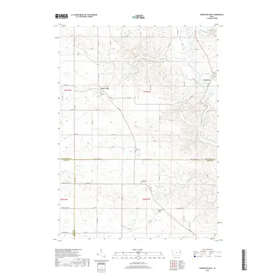
2018 Map of Hopkinton West
USGS Topo · Published 2018About this map
Hopkinton sits at the edge of this landscape where the Maquoketa River and its many tributaries, including Plum Creek and Buck Creek, carve through the Delaware County terrain. This area is characterized by a dense network of rural cemeteries that trace the settlement patterns of the region's early farming communities. In the north, the Buck Creek Cem serves the small settlement of Buck Creek, while further south, the Grove Creek Cem and Castle Grove Catholic Cem highlight the religious foundations of the surrounding townships. The map records the meeting point of Delaware, Linn, and Jones counties, marked by a straight-line grid of rural roads such as Jones Delaware Rd and Monticello Rd that contrast with the winding paths of Silver Creek and Bell Creek.
Find a feature on this map
44 named features on this map. Tap any name to fly to it.
Don’t see what you’re looking for? This feature index may not catch every label — zoom into the map to look around manually.
Map Details
Editions of this 2018 Hopkinton West Map
This is the sole edition of this map. No revisions or reprints were ever made.
Other maps of this area

1890 · Anamosa
USGS Topo · 1:62,500

1891 · Monticello
USGS Topo · 1:62,500

1900 · Anamosa
USGS Topo · 1:125,000

1959 · Dubuque
USGS Topo · 1:250,000

1961 · Dubuque
USGS Topo · 1:250,000

1962 · Dubuque
USGS Topo · 1:250,000
1965 · Dyersville West
USGS Topo · 1:24,000

1966 · Hopkinton East
USGS Topo · 1:24,000
1973 · Manchester
USGS Topo · 1:24,000
1973 · Prairieburg
USGS Topo · 1:24,000