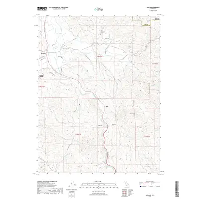
2018 Map of Hopland
USGS Topo · Published 2018About this map
Sanel Valley and the surrounding heights of the Mayacmas Mountains define this Mendocino County landscape, where the Russian River carves a path through the hills. The map highlights the distinct relationship between Hopland and its earlier counterpart, Old Hopland, situated along Dooley Cr. Agricultural interests are evident in the McDowell Valley Vineyard, tucked away in the fertile McDowell Valley. To the south, the terrain becomes increasingly complex around Squaw Rock and the prominent Squaw Rock Slide, which overlooks the river. Smaller settlements like Pieta and Duncan Springs mark the intersection of rail and road corridors. Genealogists may find the location of the Hopland Cem useful for family research, while many ranch-related roads, such as Wooldridge Ranch Rd and Hooper Ranch RD, point to the area's long-standing pastoral heritage.
Find a feature on this map
50 named features on this map. Tap any name to fly to it.
Don’t see what you’re looking for? This feature index may not catch every label — zoom into the map to look around manually.
Map Details
Editions of this 2018 Hopland Map
This is the sole edition of this map. No revisions or reprints were ever made.
Other maps of this area

1920 · Ukiah
USGS Topo · 1:62,500

1921 · Kelseyville
USGS Topo · 1:62,500

1938 · Lakeport
USGS Topo · 1:62,500

1938 · Hopland
USGS Topo · 1:62,500

1943 · Kelseyville
USGS Topo · 1:62,500

1943 · Hopland
USGS Topo · 1:62,500

1944 · Ukiah
USGS Topo · 1:62,500

1944 · Hopland
USGS Topo · 1:62,500

1947 · Santa Rosa
USGS Topo · 1:250,000

1949 · Santa Rosa
USGS Topo · 1:250,000