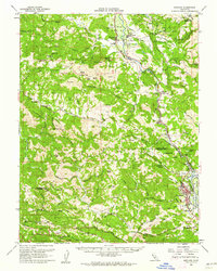
1960 Map of Hopland
USGS Topo · Published 1962About this map
The Russian River corridor anchors this 1960s study of the Mendocino and Sonoma county line, where the Northwestern Pacific Railroad and State Hwy 101 follow the valley floor. The geography shifts from the agricultural Sanel Valley in the north to the growing hub of Cloverdale in the south. Notable cultural landmarks include the Old Hopland settlement and the Hopland Indian Reservation, alongside mid-century infrastructure like a Drive-in Theater near the riverbanks.
Find a feature on this map
85 named features on this map. Tap any name to fly to it.
Don’t see what you’re looking for? This feature index may not catch every label — zoom into the map to look around manually.
Map Details
Editions of this 1960 Hopland Map
2 editions found
Other maps of this area

1920 · Healdsburg
USGS Topo · 1:62,500

1920 · Ukiah
USGS Topo · 1:62,500

1921 · Skaggs
USGS Topo · 1:62,500

1921 · Kelseyville
USGS Topo · 1:62,500

1921 · Plantation
USGS Topo · 1:62,500

1933 · Healdsburg
USGS Topo · 1:48,000

1938 · Lakeport
USGS Topo · 1:62,500

1938 · Hopland
USGS Topo · 1:62,500

1940 · Healdsburg
USGS Topo · 1:62,500

1943 · Tombs Creek
USGS Topo · 1:24,000