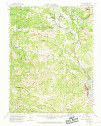
1960 Map of Hopland
USGS Topo · Published 1970About this map
The Russian River corridor serves as the primary artery for settlement and commerce through this portion of Mendocino and Sonoma Counties. The Northwestern Pacific railroad tracks hug the riverbank, connecting the town of Cloverdale in the south to Hopland and Old Hopland in the north. This transit network follows the natural break of the Sanel Valley, where agriculture is prominent at sites like Valley Oaks Farm. Evidence of cultural history and land use is found at the Hopland Indian Reservation and the Cloverdale Rancheria.
Find a feature on this map
78 named features on this map. Tap any name to fly to it.
Don’t see what you’re looking for? This feature index may not catch every label — zoom into the map to look around manually.
Map Details
Editions of this 1960 Hopland Map
2 editions found
Other maps of this area

1920 · Healdsburg
USGS Topo · 1:62,500

1920 · Ukiah
USGS Topo · 1:62,500

1921 · Skaggs
USGS Topo · 1:62,500

1921 · Kelseyville
USGS Topo · 1:62,500

1921 · Plantation
USGS Topo · 1:62,500

1933 · Healdsburg
USGS Topo · 1:48,000

1938 · Lakeport
USGS Topo · 1:62,500

1938 · Hopland
USGS Topo · 1:62,500

1940 · Healdsburg
USGS Topo · 1:62,500

1943 · Tombs Creek
USGS Topo · 1:24,000