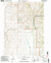
2001 Map of Hopper Gulch
USGS Topo · Published 2006About this map
Shoshone Basin characterizes this landscape in southern Idaho, where a complex network of seasonal drainages and springs defines the high-desert terrain. The map reveals a land utilized for more than just its natural features, evidenced by the presence of a Landing Strip and the Magic Hot Springs Road cutting through the western portion of the sheet. The northern section is dominated by the Sawtooth National Forest, while the southern expanse is marked by topographic markers like Alvins Well and the Spillway.
Find a feature on this map
29 named features on this map. Tap any name to fly to it.
Don’t see what you’re looking for? This feature index may not catch every label — zoom into the map to look around manually.
Map Details
Editions of this 2001 Hopper Gulch Map
This is the sole edition of this map. No revisions or reprints were ever made.
Other maps of this area

1955 · Twin Falls
USGS Topo · 1:250,000

1958 · Twin Falls
USGS Topo · 1:250,000

1965 · Hollister
USGS Topo · 1:24,000

1965 · Grand View Peak
USGS Topo · 1:24,000

1965 · Mc Mullen Basin
USGS Topo · 1:24,000

1977 · Timber Butte
USGS Topo · 1:24,000

1977 · Big Creek Ranch
USGS Topo · 1:24,000

1977 · Rogerson
USGS Topo · 1:24,000

1977 · Magic Hot Springs
USGS Topo · 1:24,000

1978 · Hopper Gulch
USGS Topo · 1:24,000