1958 Map of Hoquiam
USGS Topo · Published 1975About this map
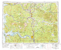
The Columbia River forms a massive liquid border at the base of this survey, where the Coast Range meets the Pacific tides at Grays Harbor and Willapa Bay. This mid-century landscape is defined by its deep timber and river commerce, showing the Burlington Northern rail lines connecting timber towns like Hoquiam, Aberdeen, and Centralia. The map captures the extensive public lands of the era, from the Capitol State Forest near the state capital to the vast reaches of the Snoqualmie National Forest and Gifford Pinchot National Forest in the east. Of particular interest to historians is the detailed depiction of the Nisqually Ind Res and the military grounds of Fort Lewis Mil Res, alongside numerous rural landings and crossings like Cathlamet and Skamokawa that once served as vital hubs for the local river-and-rail economy.
Find a feature on this map
204 named features on this map. Tap any name to fly to it.
Don’t see what you’re looking for? This feature index may not catch every label — zoom into the map to look around manually.
Map Details
Editions of this 1958 Hoquiam Map
2 editions found

Other maps of this area

1897 · Tacoma
USGS Topo · 1:125,000

1900 · Tacoma
USGS Topo · 1:125,000

1913 · Cedar Lake
USGS Topo · 1:125,000

1916 · Chehalis
USGS Topo · 1:125,000

1919 · Mayger
USGS Topo · 1:62,500

1919 · Mount St Helens
USGS Topo · 1:125,000

1919 · Astoria
USGS Topo · 1:62,500

1921 · Kalama
USGS Topo · 1:62,500

1922 · St. Helens
USGS Topo · 1:62,500

1924 · Mt Rainier
USGS Topo · 1:96,000