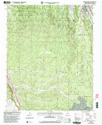
2002 Map of Horcado Ranch
USGS Topo · Published 2003About this map
The complex boundary lines of Native American land grants and tribal reservations define this high-desert landscape north of Santa Fe. In the early 21st century, these borders reveal a patchwork of historical land tenure, including the San Ildefonso Pueblo Grant, Pojoaque Pueblo Grant, and the Tesuque Pueblo Grant. The terrain rises from the Rio Tesuque valley toward the dramatic Caja Del Rio Plateau and the deeply incised drainage of Cañada Ancha. Human infrastructure is sparse but critical, evidenced by the Norton Substation, a Pipeline, and an Aqueduct crossing the arid expanses. While the settlement of Cuyamungue sits near the river, more remote sites like Horcado Ranch and the residential area of Las Dos are reached via light-duty roads and 4WD trails that navigate the brushy canyons of the Santa Fe National Forest.
Find a feature on this map
27 named features on this map. Tap any name to fly to it.
Don’t see what you’re looking for? This feature index may not catch every label — zoom into the map to look around manually.
Map Details
Editions of this 2002 Horcado Ranch Map
This is the sole edition of this map. No revisions or reprints were ever made.
Other maps of this area

1889 · Santa Fe
USGS Topo · 1:125,000

1892 · Santa Clara
USGS Topo · 1:125,000

1894 · Santa Fe
USGS Topo · 1:125,000

1951 · Agua Fria
USGS Topo · 1:24,000

1952 · Santa Fe
USGS Topo · 1:24,000

1952 · White Rock
USGS Topo · 1:24,000

1952 · Puye
USGS Topo · 1:24,000

1952 · Montoso Peak
USGS Topo · 1:24,000

1953 · Tesuque
USGS Topo · 1:24,000

1953 · Espanola
USGS Topo · 1:24,000