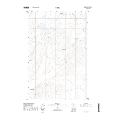
2020 Map of Horse Lake
USGS Topo · Published 2020About this map
Milk River Ridge dominates the central topography of this Glacier County landscape, serving as a significant drainage divide for the regional watershed. To the north, the terrain is defined by the S Fork Milk River and stationary water bodies including Horse Lake and Toad Lake. South of the ridge, the land transitions into an intricate network of waterways, featuring the N Fork Greasewood Cr, Middle Fork Greasewood Cr, and S Fork Greasewood Cr. The presence of the Cut Bank Greasewood Canal in the southeast corner reflects the critical role of water management in this high-plains environment. Local ranching and transport history is represented by several remote tracks such as Duck Lake Rd and Arnoux Trl, while numerous named coulees like Madman Coulee and Spring Coulee underscore the erosive power of the elements over time.
Find a feature on this map
30 named features on this map. Tap any name to fly to it.
Don’t see what you’re looking for? This feature index may not catch every label — zoom into the map to look around manually.
Map Details
Editions of this 2020 Horse Lake Map
This is the sole edition of this map. No revisions or reprints were ever made.
Other maps of this area

1901 · Browning
USGS Topo · 1:125,000

1903 · Browning
USGS Topo · 1:125,000

1960 · Cut Bank
USGS Topo · 1:250,000

1963 · Cut Bank
USGS Topo · 1:250,000

1964 · Cut Bank
USGS Topo · 1:250,000

1968 · Josephine
USGS Topo · 1:24,000
1968 · Kiowa
USGS Topo · 1:24,000

1968 · Hoodoo Hill
USGS Topo · 1:24,000
1968 · Duck Lake
USGS Topo · 1:24,000

1968 · Browning NE
USGS Topo · 1:24,000