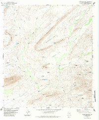
1983 Map of Horse Mountain
USGS Topo · Published 1984About this map
The Haymond Mountains and Pe Na Blanca Mountains anchor this high-desert terrain in Brewster County, where life in the 1970s and 1980s centered around scattered water sources. This landscape is defined by its network of named windmills and tanks, essential for ranching in such an arid climate. Features like the Boots Windmill, Granger Cove Windmill, and Cry Baby Windmill dot the basins between peaks, while more colorful landmarks such as Dead Horse Hole and Dead Cow Hole suggest the harsh realities of this environment. To the south, the Devils Backbone rises above San Francisco Creek, complemented by the evocative names of Half Acre and Hells. A solitary Landing Strip near Fighting Flat serves as a reminder of the vast distances and the reliance on air travel for reaching these isolated West Texas outposts.
Find a feature on this map
41 named features on this map. Tap any name to fly to it.
Don’t see what you’re looking for? This feature index may not catch every label — zoom into the map to look around manually.
Map Details
Editions of this 1983 Horse Mountain Map
This is the sole edition of this map. No revisions or reprints were ever made.
Other maps of this area

1917 · Hood Spring
USGS Topo · 1:62,500

1918 · Bone Spring
USGS Topo · 1:125,000

1918 · Hood Spring
USGS Topo · 1:62,500

1918 · Dove Mountain
USGS Topo · 1:62,500

1920 · Longfellow
USGS Topo · 1:125,000

1920 · Marathon
USGS Topo · 1:62,500

1921 · Marathon
USGS Topo · 1:62,500

1931 · Hood Spring
USGS Topo · 1:62,500

1954 · Fort Stockton
USGS Topo · 1:250,000

1958 · Fort Stockton
USGS Topo · 1:250,000