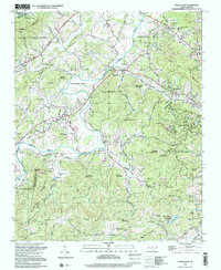
1997 Map of Horse Shoe
USGS Topo · Published 2001About this map
The French Broad River carves a dramatic path through this Henderson County landscape, defining the character of Horse Shoe and its famous Horse Shoe Bend. The river valley, flanked by the Pisgah National Forest to the northwest and the rising summits of Jumpoff Mountain and Hebron Mountain to the east, serves as a corridor for historical settlement. Community life is anchored by numerous rural landmarks, including Forge Valley Ch and Pleasant Grove Ch, alongside several family burying grounds such as the Aiken Cem and Orr Cem.
Find a feature on this map
110 named features on this map. Tap any name to fly to it.
Don’t see what you’re looking for? This feature index may not catch every label — zoom into the map to look around manually.
Map Details
Editions of this 1997 Horse Shoe Map
This is the sole edition of this map. No revisions or reprints were ever made.
Other maps of this area

1905 · Pisgah
USGS Topo · 1:125,000

1906 · Pisgah
USGS Topo · 1:125,000

1907 · Saluda
USGS Topo · 1:125,000

1935 · Brevard
USGS Topo · 1:24,000

1935 · Standingstone Mtn.
USGS Topo · 1:24,000

1935 · Horse Shoe
USGS Topo · 1:24,000

1935 · Hendersonville
USGS Topo · 1:24,000

1935 · Zirconia
USGS Topo · 1:24,000

1935 · Pisgah Forest
USGS Topo · 1:24,000

1936 · Skyland
USGS Topo · 1:24,000