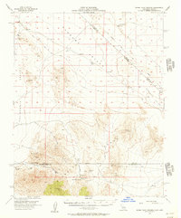
1956 Map of Horse Thief Springs
USGS Topo · Published 1957About this map
The Kingston Range dominates the southern half of this mid-century survey, where the arid borderland between California and Nevada reveals a landscape defined by mining activity and vital water sources. Numerous mineral claims are scattered across the high terrain, including the Silver Rule Mine, Blackwater Mine, and the Snow White Mine. These industrial outposts relied on a network of isolated springs and tanks, such as Crystal Spring and the namesake Horse Thief Springs located near Tecopa Pass.
Find a feature on this map
22 named features on this map. Tap any name to fly to it.
Don’t see what you’re looking for? This feature index may not catch every label — zoom into the map to look around manually.
Map Details
Editions of this 1956 Horse Thief Springs Map
3 editions found
Other maps of this area

1907 · Las Vegas
USGS Topo · 1:250,000

1908 · Furnace Creek
USGS Topo · 1:250,000

1908 · Las Vegas
USGS Topo · 1:250,000

1910 · Furnace Creek
USGS Topo · 1:250,000

1910 · Ivanpah
USGS Topo · 1:250,000

1912 · Ivanpah
USGS Topo · 1:250,000

1933 · Avawatz Mountains
USGS Topo · 1:250,000

1942 · Ivanpah
USGS Topo · 1:250,000

1947 · Trona
USGS Topo · 1:250,000

1947 · Kingman
USGS Topo · 1:250,000