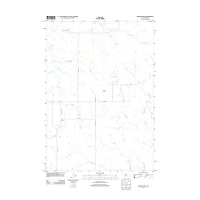
2012 Map of Horse Tooth
USGS Topo · Published 2012About this map
Saint Paul Cem sits as a quiet landmark in this ranching landscape of western South Dakota. The terrain is defined by a dendritic network of drainages, where Poeno Cr and the N Fork Bad River carve through the plains. Local water management is evident through features like the Kirk Cordes Number 10 Reservoir and Willuweit Dam Number 10 Reservoir, which support the livestock operations central to the region.
Find a feature on this map
19 named features on this map. Tap any name to fly to it.
Don’t see what you’re looking for? This feature index may not catch every label — zoom into the map to look around manually.
Map Details
Editions of this 2012 Horse Tooth Map
This is the sole edition of this map. No revisions or reprints were ever made.
Other maps of this area

1953 · Rapid City
USGS Topo · 1:250,000

1954 · Pierre
USGS Topo · 1:250,000

1955 · Creighton
USGS Topo · 1:24,000

1955 · Pedro SE
USGS Topo · 1:24,000

1957 · Rapid City
USGS Topo · 1:250,000

1958 · Pierre
USGS Topo · 1:250,000

1983 · Post Ranch
USGS Topo · 1:24,000

1983 · Philip
USGS Topo · 1:100,000
1983 · Grindstone
USGS Topo · 1:24,000
1983 · Horse Tooth
USGS Topo · 1:24,000