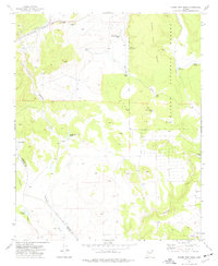
1973 Map of Horse Trap Mesa
USGS Topo · Published 1977About this map
The Atchison Topeka and Santa Fe railroad corridor cuts through the high desert plateau in this 1970s survey, marking a vital transit line across northern Arizona. The landscape is defined by the high ground of Horse Trap Mesa and the eastern reaches of the Kaibab National Forest, where the terrain is carved by seasonal drainages like Partridge Creek and Eightmile Creek.
Find a feature on this map
28 named features on this map. Tap any name to fly to it.
Don’t see what you’re looking for? This feature index may not catch every label — zoom into the map to look around manually.
Map Details
Editions of this 1973 Horse Trap Mesa Map
This is the sole edition of this map. No revisions or reprints were ever made.
Other maps of this area

1886 · Chino
USGS Topo · 1:250,000

1891 · Chino
USGS Topo · 1:250,000

1922 · Williams
USGS Topo · 1:125,000

1947 · Ash Fork
USGS Topo · 1:62,500

1947 · Picacho Butte
USGS Topo · 1:62,500

1948 · Ash Fork
USGS Topo · 1:63,360

1948 · Williams
USGS Topo · 1:250,000

1948 · Picacho Butte
USGS Topo · 1:63,360

1949 · Ash Fork
USGS Topo · 1:62,500

1950 · Picacho Butte
USGS Topo · 1:62,500